
Professor in Residence, Department of Architecture, GSD, Harvard University, Cambridge MA, USA
Policy
Open Access
Type
Project
Section
CROSS-DISCIPLINARY STUDIES
ABSTRACT -
The development of a landscape architecture project that contains a scientific research and tourism station is being considered in an extreme territory – dynamic, isolated, hard to access - in Exploradores, western Aysén, southern Chile. The territorial characteristics, lack of infrastructure, and limited information about the place to be intervened into mean that its landscape – the subject of this work- is hard to define. This situation leads the research into the development of a first part – analytical, descriptive, and speculative - which will define the remote landscapes of Exploradores, which are not observed physiologically in the territory.
The first part will be complemented by the landscape architecture project, which proposes, by architectural insertions, to interpret and express the situation that has been recognized. Supported by a methodology that studies the territory with a four-scale approach, representative aspects of the local landscape will be determined that seek to function as an operative tool guiding decisions for the project.
Keywords
The Region of Aysén is located in the midst of the far southern territory of Chile, between 43º and 49º South latitudes. There are diverse physical landscapes in that part of the country. On the coast there is an infinite number of islands and islets that form intricate archipelagos in fragmented continuity of the Coastal Mountain Range (Fig. 2). The intermediate depression, which takes the form of fertile valleys in the rest of the country, disappears here to give way to the Moraleda Canal. The Andes Mountains are also different from their structure in the rest of Chile, as they lose altitude significantly and have been modeled by glacier activity, containing large ice fields. The region has a wide diversity of ecosystems and contains more than five million hectares of national parks, but the extreme location of this territory has meant that its economic and social development has been slower than in other regions of the country.
In between architecture, territory, and landscape
According to the Interministerial Committee for the Development of Extreme and Special Zones (CIDEZE),1 a territory may be considered extreme because of such factors as critical isolation, small and disperse population, poor accessibility, deficient presence of public administration, and low level of socioeconomic development, or because it suffers from a deficit in road, port, airport and telecommunications infrastructure.
All of those characteristics are present in Aysén. One can see, however, that they are the result of a bigger reason that encompasses a large part of the territory of the region, mainly on its western side, which is the dynamism of the territory, climatically, geomorphologically, and environmentally, which makes it a fragile and unstable territory for human habitation.
On the other hand, the roads and populated centers are currently grouped mostly on the eastern side of the region, as a result of the disjointed geography of the western side, which is largely unoccupied, with difficult access to the interior and large surfaces that remain free of intervention.

Figure 1.
1
The region of Aysén within the territory of Chile.
This research arose from the commission to develop a landscape architecture project as part of the program of a scientific research and tourism station in the sector of Exploradores, a valley that culminates in a bay in western Aysén.2 The territorial characteristics, lack of infrastructure, and limited information about the place to be intervened make its landscape – the subject of the work – hard to define.3 This situation leads the research to develop a first part – analytical, descriptive, and speculative–, which will define the "remote landscapes" of Exploradores, which cannot be easily observed physiologically in the territory.
The analysis and conclusion of the first part will guide the development of the architecture project, influencing its implementation and, therefore, its form and the way it is located in the place. Thus, the categorization of “extreme territory” does not only suggest that it is difficult for man to live in those territories as a result of their determining physical, geographic and social conditions, but it should also promulgate an interest in new forms of settlement in those territories that arise from the differentiated development of those spaces and their inhabitants.4

Figure 2.
2
Chonos Archipelago, West Aysén. Elisée Reclus, 1879-94.
Architecture in Extreme Territories: Differentiation of Two Kinds of Settlement Based on the Landscape
Although it is interesting in architecture the way human beings have settled in extreme territories, a new differentiation arises among these kinds of settlement. There are some kinds of settlement where their form and placement only answer to practical territorial facts for inhabiting and maintaining a program, and some that answer, as well, to a landscape that is dominated by its architectural form and its location.
Agustin Berque, in his search to recognize indications that mark the birth of the landscape, adopts six criteria that, in his opinion determine whether a culture has integrated "thinking through landscape."5 One of these criteria is “architecture planned to enjoy beautiful views.”6 Based on that criterion, he makes a distinction between constructions of different cultures, some that materialize a view of the outdoors, like the asqqif 7 of the Alto Atlas in the Seksawa valley (Morocco), and others that make the view converge on an interior courtyard, like Roman villas or Arab houses.
Likewise, returning to the territory being studied, one can see constructions in Patagonia that aim their view at the landscape, where this is the subject of a project, and others that concentrate their view inwards, defensively, ignoring the landscape (Fig. 3a, 3b).
This orientation for the landscape from architecture is seen less frequently in Aysén than in other regions and provinces of Patagonia, like Magallanes, with a recognized architecture of estancias,8 where galleries look outwards, as a result of the implementation of European architectural models.9 Based on local contemporary architecture in Aysén, on the other hand, we can see that the landscape is undervalued as a natural resource of the territory, but not the material resources that can be extracted from it, as expressed in the woodwork used in its architecture.
In addition to undervaluing the landscape in the region, this is an "extreme territory", a characteristic that especially affects its western side and consists of difficult accessibility to the interior, producing an absence of visual landscape in an important percentage of the surface area. This factual condition of the physical space leads us to wonder how to reveal the landscapes of a territory that cannot be seen by human beings in order to make it serve a productive use in the sciences and tourism.
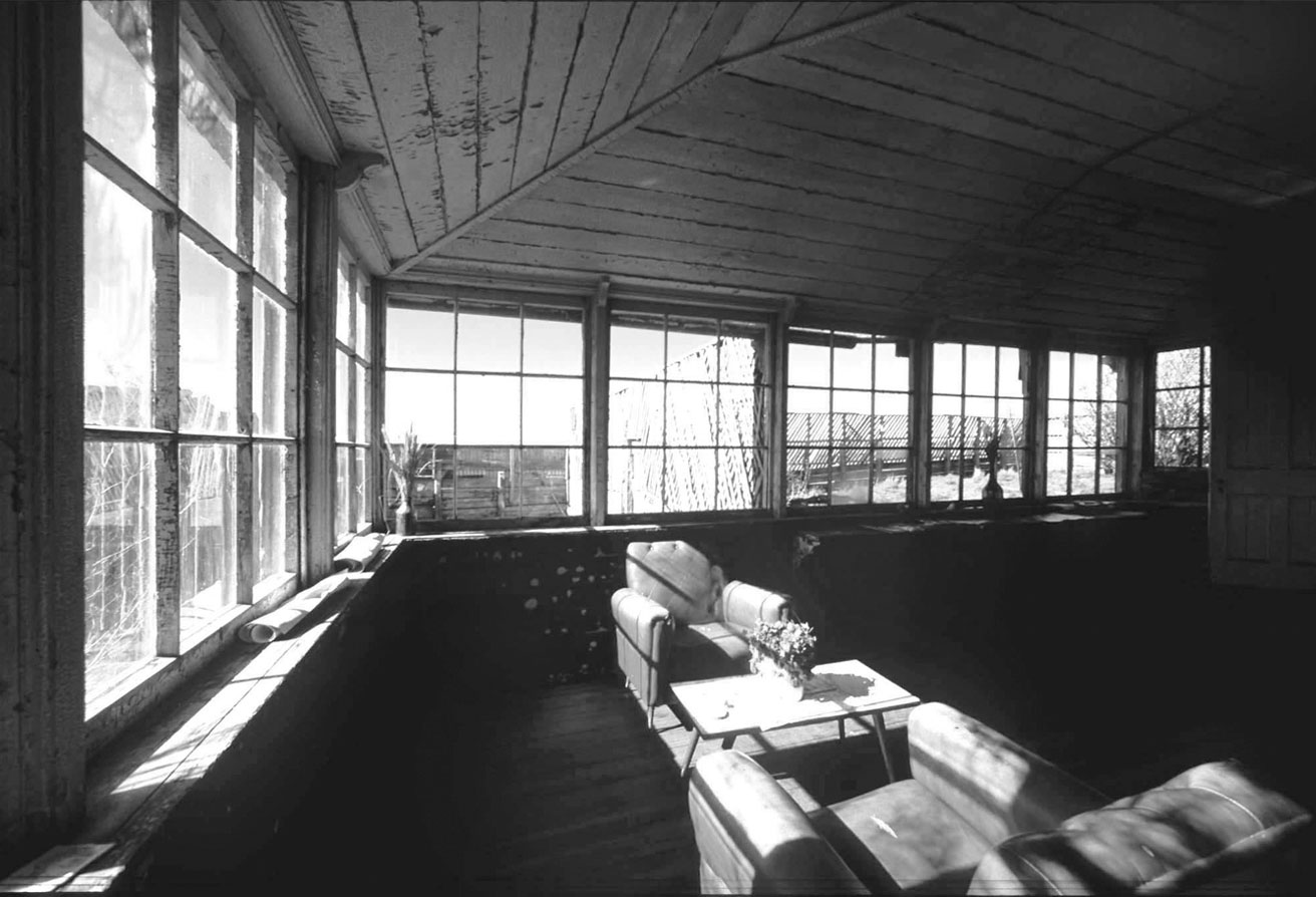
Figure 3a.
3
Patagonian estancia in Magallanes.
Figure 3b.
32
Settler´s house in Aysén.
Landscape: Vision and Representation
Two dominant forces have been identified in the practice of landscape architecture that, paradoxically, are not closely related to the case being studied: the first is the intention to “re-naturalize” places that have been drastically intervened into through transformation of their ecology, and the second is the revaluing of the cultural heritage of places, as interpreters of history and human interventions in the territory.
Here we are dealing with the opposite of what has traditionally been undertaken by the discipline, considering that in this context considerable extensions of territory have been preserved. Thus, the problem facing this landscape project is related to the intention to intervene in an unaltered place, preserving its original ecology, but giving a productive use to its landscapes, which starts by making it part of a cultural notion.
The first condition that is necessary for there to be a landscape and for it to be available to humans, is the possibility of seeing it. As we know, the term landscape in the West comes from the Latin word pagus, which refers to an occupied territory: countryside, district or town.
Nevertheless, although landscape can be understood as a concrete medium that can be described and manipulated, it is also pertinent to consider its subjective character, “that which is not found in the object, but in the look; (…) and requires prior cultural training as a conditioning basis.”10
This "prior cultural training" is based on the knowledge or imagery we have about a territory, which is the reality, or actual truth – and therefore subjective – that will orient the relationship we establish with each place.
Even geography begins by dealing with the visible aspects of those relationships, as a discipline that examines relationships between forms of human occupation and either natural or created spaces, but then, in the framework of cultural geography, landscape has evolved from being “a reference to the tangible, a measurable set of material forms in a specific geographic area,” to “a representation of those forms in varied media,” to becoming “the desired, remembered and somatic spaces of the imagination and the senses.”11 The concept may be applied, therefore, to those three situations: what is measured, represented and imagined, and each situation shaping it.
We could then include the definition of the term in this description from Michel Collot:
"Landscape is a junction where elements come together from nature
and culture, geography and history, the interior and the exterior,
the individual and the collectivity, the real and the symbolic."12
Remote Landscapes
By "remote landscape" we shall understand the image – mental or graphic, individual or collective – representative of unforeseen physical spaces corresponding to extreme or little known territories.
The unforeseeable – that which cannot be foreseen – may be associated with the dynamic conditions of territories and the difficulty in accessing them and, therefore, seeing them. This is reflected in the fact that those landscapes evoke territories that are recognized as distant, unfamiliar, unexplored, and about which there is little information. In those cases, the image of a place is not formed mainly by a sense of vision but by conjectures and deductions.
In general, working with landscapes involves dealing with the unforeseeable, because of the multiple layers that overlap and are in constant change. However, "remote landscape" refers to landscapes whose territorial complexity means they are also hard to see, where their collective knowledge has been constructed by the description of a few people.
Art and the sciences are some disciplines that have contributed to shaping remote landscapes and their cultural valuation.13 By an aesthetically or scientific work, they have conquered those distant, unknown landscapes, like the mountains, the coast, and the forests for the rest of society, participating in the social appropriation of the territory, creating admiration for scenery, or revealing – or suggesting – some mysteries.
Thus, although a "remote landscape" may not have anthropic interventions that denote a culture typical of that territory, through representations or accounts that have been provided of those places we can recognize a cultural view that may provide the basis for a landscape.
That is what happened in a large part of the far southern territory of Chile, which was colonized late, but there are records of explorations that relate the way the landscapes started to be shaped by the different eyes that described the territory. Colonizing expeditions told how hard it was to settle those territories; expeditions to establish borders reported on navigable routes and landfalls; missionary expeditions addressed the history of the aborigines and the way of life in those extreme territories; scientific expeditions charted the geography and the environment that characterized them.
The territory of Patagonia was seen through non-native eyes for the first time in 1501 by the expedition led by Amerigo Vespucci. Successive explorations followed. The first representations of those far southern territories date from the first half of the fifteenth century, and until the mid-nineteenth century the cartography combined empirical geographic notions with symbolic drawings that portrayed the cultural context of the moment, or the author, and gave ideas of the place subject to the observer´s experience (Figs. 4, 5).

Figure 4.
4
Royaume de Ginganton -Terre Australe, Guillaume Le Testu, 1555.

Figure 5.
5
Falkland and Patagonia, John Rapkin, 1851.
Compiling that information enables us to distinguish how those landscapes were shaped on the basis of the languages of each culture, empirical data, legends, and experiences, which were then used and complemented by the following expeditions. Thus, it is clear that shaping a remote landscape also takes place sequentially, with each approach shedding light on the next one, until those lands can be comprehended, controlled, and visited.
Today, with the opening of roads and construction of infrastructure some of those landscapes have already been revealed as "visual landscapes," while others still remain "remote landscapes."
FORMING THE EXPLORERS’ LANDSCAPE
We have understood the logic of the sequence in the creation of a remote landscape, as this occurs from the ecological perspective.
When studying the ecology of landscapes and regions, Richard T.T. Forman refers to the principle of space-time, which implies that a phenomenon at broad scale is more persistent and stable than those at fine scale. On the contrary, fine-scale phenomena should be more variable in time and space.14 Those observations encourage us to analyze the territory of Exploradores at different scales of approach: the regional, the valley, the bay, and the marsh (the latter will be the site of the architectural program), where each one is representative of dynamics with different rhythms and effects, but they are affected by the ones that precede them. This methodology is also applied considering that it would be difficult to establish a single limit on the analysis of the territory of Exploradores as its processes are related at different scales. Thus, an attempt is made to form the landscape of Exploradores on the basis of a system of landscapes at different scales (Fig. 6).
Scale 1: Region of Aysén: Landscape of Contrasts
With the information that has been collected, representative of the regional scale, we see a landscape that is understood and measured on the basis of its contrasts, clearly marked between the eastern and western sides. The problem in moving around the region and accessing its visual landscapes lies in the fact that its roads run north-south. The roads that cross it are few, and they run almost exclusively to the eastern side of the region.
This observation shows the importance of opening up new roads that cross the region from east to west, which would make the eloquence of the landscape that much greater. We are encouraged to propose routes that, besides serving their primary function as connectors, would operate as scientific and scenic transects; in other words, their paths would cross the territory in a way that would help to understand its diversity of forms and components, highlighting its contrasts.
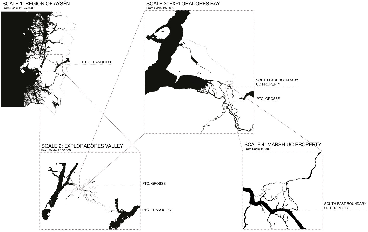
Figure 6.
6
Four scales of approach to the territory.
Scale 2: Exploradores Valley: Crossing Landscape
The Exploradores Valley runs east-west across the region, at the 46th parallel south latitude, bordering Campo de Hielo Norte. Besides crossing the region east to west, as a periglacial valley, it uncovers a number of phenomena that make it very valuable both scenically and scientifically. Those discoveries have been made because of the construction of a road over 15 years ago, which is currently being finished.
The road itself becomes, therefore, not only a connecting infrastructure, but also, as Careri proposes, its route becomes a form of expression of the place, and the act of crossing becomes an instrument of knowledge and symbolic interpretation of the territory.15
To study the variability and scenic value of the valley, the route is studied as a transect that crosses the region from east to west, and reveals, during the crossing, a landscape that acquires consistency by combining the scenic view with scientific understanding (Fig. 7).
The transect is a methodological resource of observation that consists of a line drawn over a territory where transitions are distinguished, where the area that is being crossed is recorded. These ecological models enable us to interpret the territory and realize that, if we are going to affect that part of the territory, repercussions will be felt on other parts of the system.

7
Figure 7. Crossing the Exploradores Valley.
Scale 3: Exploradores Bay: Border Landscape
Bahía Exploradores is located on the western side of the region of Aysén, which is characterized by a predominant marsh composed of fjords and canals. Here, the dense vegetation, steep geography, and undulating bodies of water are some of the factors that have made it hard to penetrate overland to the interior of the fragmented territory. A large percentage of the land has not been transformed at all and lies beyond human view.
In light of the limitations on human view, close and distant views are differentiated, and dynamic processes are identified in each one at different scales of space and time. In close views, in proximity to the territory, daily change in tides and an intertidal area with intense activity involving exchange and biological adjustment can be seen. In distant views, on the other hand, by moving away from the territory, the main mountain peaks and the topography are recognized as well as changes in vegetative structure according to the altitude, types of soil, and erosion.
This situation has determined that the area´s visual landscapes are limited to what can be seen from the waters surrounding them, which function as a form of transportation infrastructure that people can travel on by boat. The landscape, framed within those limitations, appears as a landscape of borders that can be seen according to how near or far one is from the perimeter that extends to the sea.
Scale 4: Marsh: Transition Landscape
A marsh is an ecosystem where there is an exchange of fresh water and salt water, which flood periodically because of changes in the condition of the water, affected by tides, melt water or excessive precipitation. Varied ecological transitions take place in marshes that have an effect on changes in the physical and vegetative structure of the territory. This quality of the marsh enables us to identify a landscape in continuous change, which requires an architecture that adapts to the typical conditions of a transition landscape.
The study at that scale of approach was focused on defining the most favorable areas for the main programs of the Research Station, and on defining areas of interest for future study, which would reinforce its scenic value. It is interesting to identify different types of transition in the land, and then to explore them with an architecture that enables us to get closer to them.
The project is formulated as means of exploration that investigates the potential of landscape architecture as a medium of expression of remote landscapes: dynamic, little known, hard to access.
FROM REMOTE LANDSCAPES TO THE ARCHITECTURAL PROJECT
After configuring those remote landscapes, we will be able to work on them with the intent to unify, between the empirically existing space, the imagined space – the result of deductions and speculations – and the desired space, which would materialize with the project.
With the analysis of those four scales of approach to the territory, the landscape of Exploradores is characterized as a landscape of contrasts, crossing, borders, and transitions (Fig. 8).
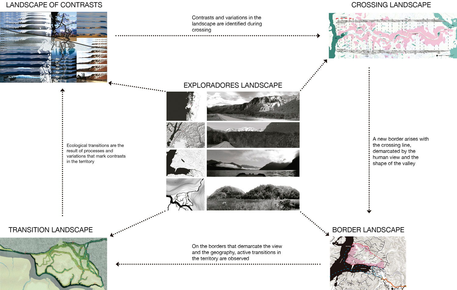
Figure 8.
8
Exploradores landscape diagram.
In order for the landscape architecture project to establish an account of the general landscape of Exploradores, which ranges from the regional scale to the scale of an ecotone in an inter-tidal space, the project is developed maintaining these characteristics:
1) Highlight contrasts: the contrasts that are present in the forms and processes of the land and the ones that will be created between construction and nature, differentiating an area that shelters human activity and an area in the open air that exposes the rigors of this extreme territory.
2) Cross the territory and move around it to show a representative section of a variable and dynamic landscape in those lines of penetration.
3) Generate new borders of approach to landscapes, demarcated by the viewing area permitted by the position of the project before the landscape.
4) Place the project on the borders of ecological transition so that an account can be established on its route and crossings, on a close scale, about the general landscape of Exploradores. (Figs. 9-11).

Figure 9.
9
Breakdown of main marsh ecosystems.

Figure 10.
10
Location of the project with different marsh conditions.

Figure 11.
11
Location and program for scientific research and tourist station.
Architectural Insertions
We have referred to the landscape in relation to vision and representation, making a distinction between "visual landscapes" – the ones that can be seen, involving one´s own experience – and "remote landscapes" – the ones that are visualized in the imagination, generated on the basis of representations, descriptions or accounts of a few people. That distinction appears when we wonder how to access remote landscapes visually, which have been recognized as having an implicit value since they exist as a cultural notion.
In response to that problem, the concept of "architectural insertion" arises, which suggests a dialogue between remote and existential landscapes, establishing itself as a mediator between the two. It is referred to as insertion, because from its condition unconnected to natural physical space it attempts to work on landscapes – what is seen and its significance – rather than on the territory, so the latter conserves the typical characteristics that confer value on its landscapes (Fig. 12).
An architectural insertion is understood as a new layer of anthropic use that is set in a place and takes a position in it, attempting not to interrupt natural processes by adapting to them. It takes the form of an infrastructure that permits the entry and permanence of humans in extreme territories that otherwise would not permit it.
The role played by a landscape architect, like an artist that represents those landscapes, is that the architect has the choice of working with strategies that reinforce the original character of the landscape with a personal, but comprehensive, view of the territory to be intervened into, recognizing that the proposed project has the potential of becoming one more element in shaping the landscape.

Figure 12.
12
Cross section of modules.
Design Principles
Thus, the project will include the following principles, in relation to the vision and limits of the view; in relation to the need for a surface area that faces us with something that is not accessible; and in relation to the incorporation of time and movement in the experience of the space:
1) The architecture will enable and frame views of the landscape, operating like a viewer, which directs the eye like the asqqif of the Seksawa, but where the spectator with his own experience, knowledge, and interests is the party who will determine the landscape that he is looking at. And nature itself will place limits on the vision, with views that are more closed and others that are more open, but understanding that both views can be equally broad, although they are on opposite scales (Figs. 13a, 13b).
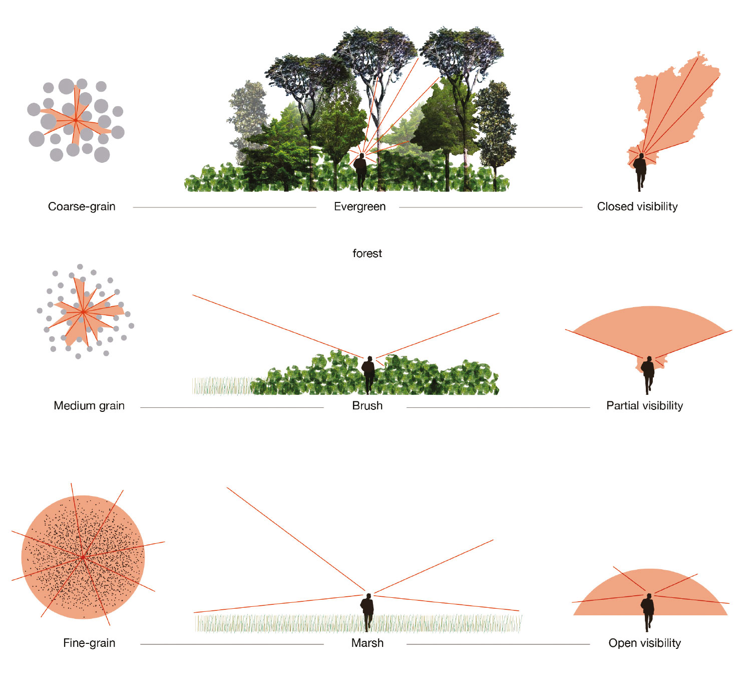
Figure 13a.
131
Visibility study (a).

Figure 13b.
132
Visibility study (b).
2) The project for this extreme territory shall include an easy-to-assemble platform system, with prefabricated components, that generate stable soil and absorb the different conditions of each site to which access is sought. This system of platforms will raise constructions off the surface of the natural soil. The project will be formulated as an insertion, a new layer that is placed on top of the territory and makes it possible to access its landscapes without blocking its processes (Figs. 14a, 14b, 14c, 14d, 15a, 15b).
3) The platforms will be attached to pedestrian walkways that make it possible to walk around the territory, adapting to its processes in order to experience its landscapes, discovering a dynamic territory. The route of these walkways should not be random, it should be illustrative of the place to be worked on and reflect a reading of territorial gestures (Figs. 16, 17).
Through the operation of working with "architectural insertions" in the territory, a kind of symbiosis between the natural and artificial will occur, as the project alone, without the environment, would not work, and the landscape, without the project, would be relegated to its remote condition. Thus, both the proposed project and the ecology of the landscape should be differentiated as systems that are distinct but constitutive of one another
(Figs. 18a, 18b, 19, 20, 21).

Figure 14a.
141
Components of structural modules (a).
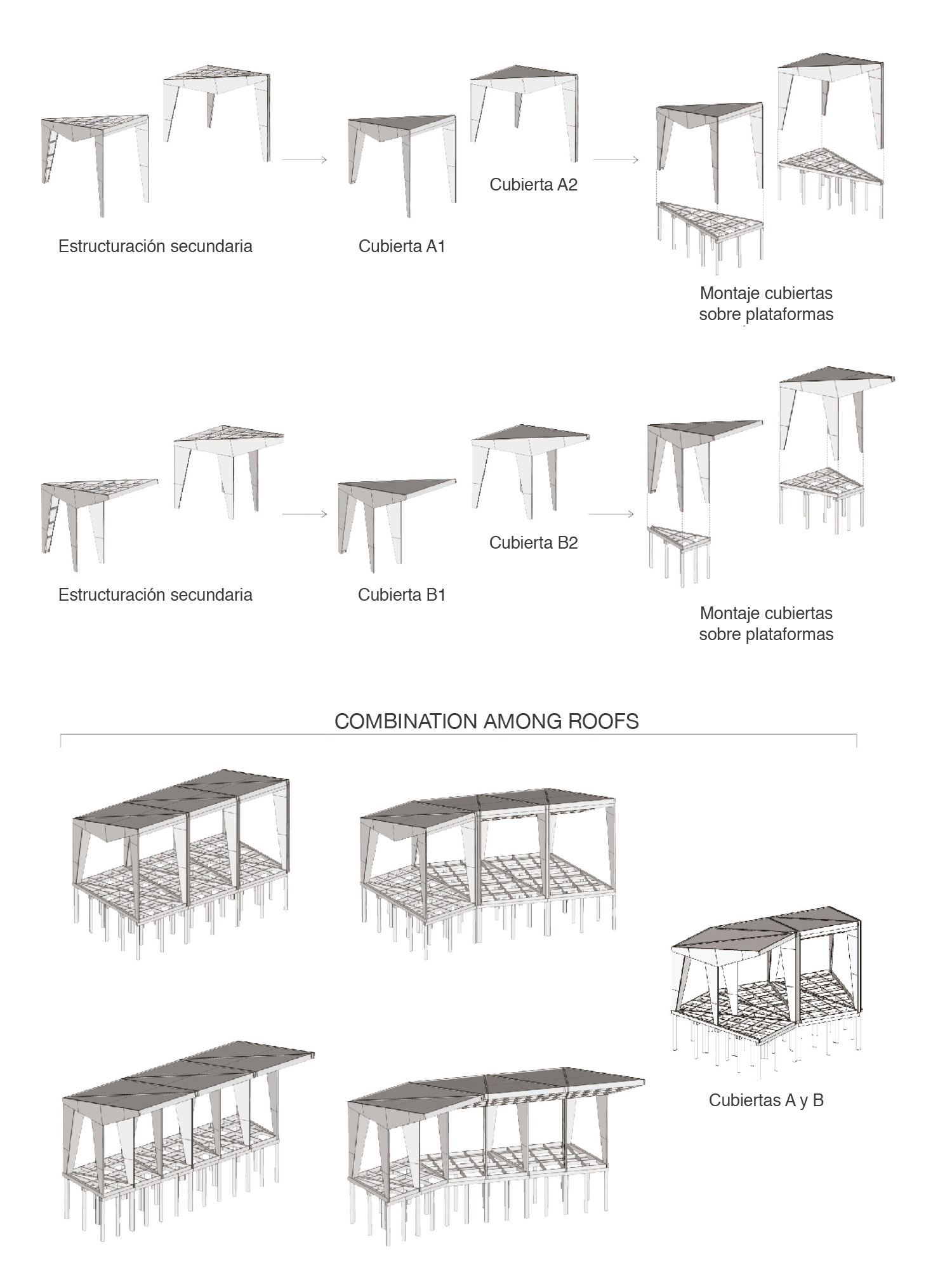
Figure 14b.
142
Components of structural modules (b).

Figure 14c.
143
Components of structural modules (c).
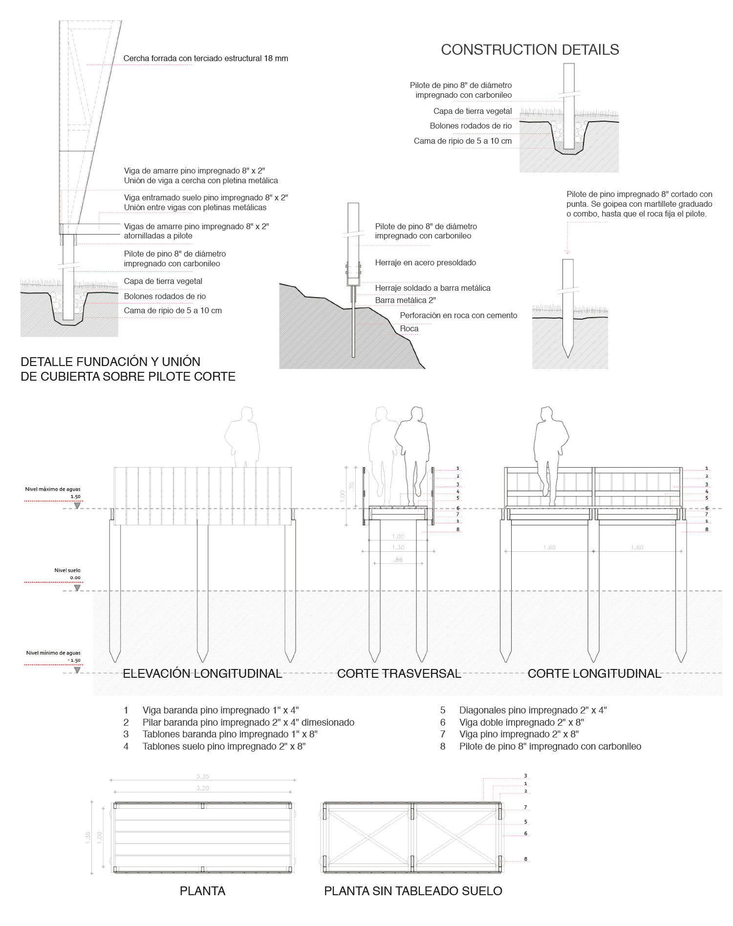
Figure 14d.
144
Components of structural modules (d).

Figure 15a.
151
Modular roofs combinations (a).
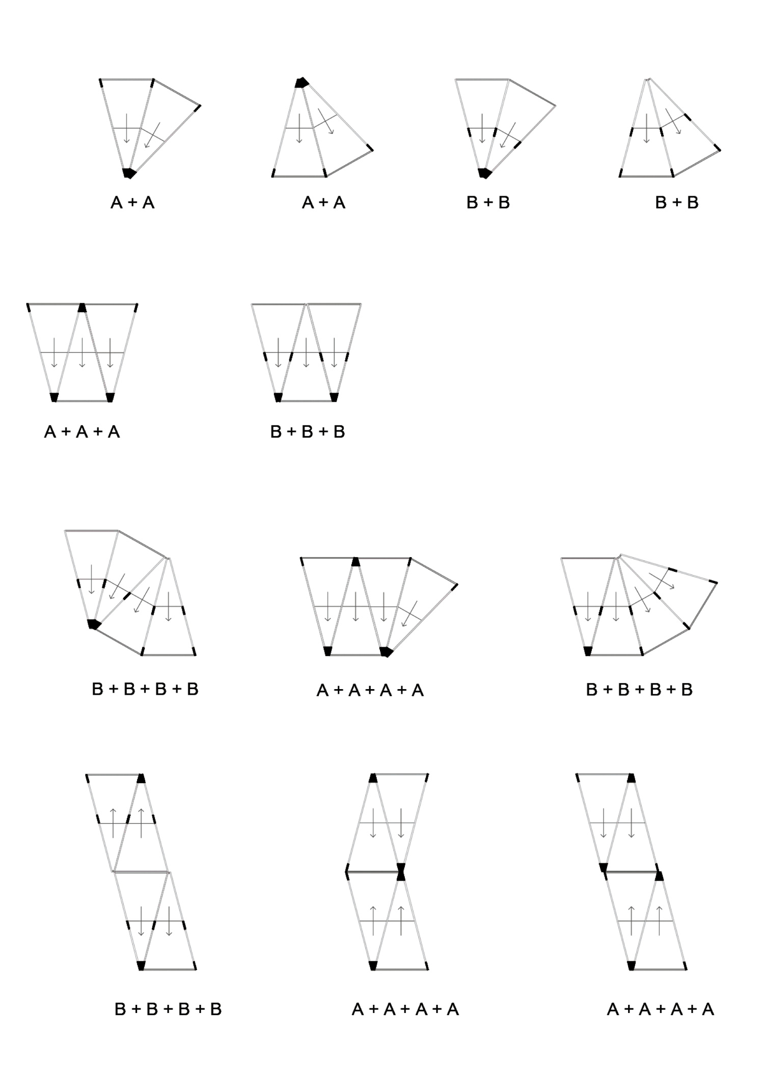
Figure 15b.
152
Modular roofs combinations (b).

Figure 16.
16
Site conditions.

Figure 17.
17
Modules in different site conditions.

Figure 18a.
181
Major program plans (a): the Dock and the Research Pavilion.

Figure 18b.
182
Major program plans (b): the Inn.
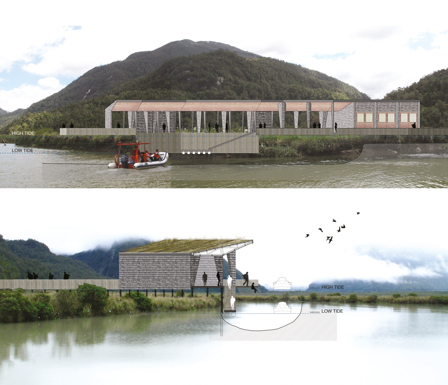
Figure 19.
19
Dock sections.

Figure 20.
20
Inn sections.
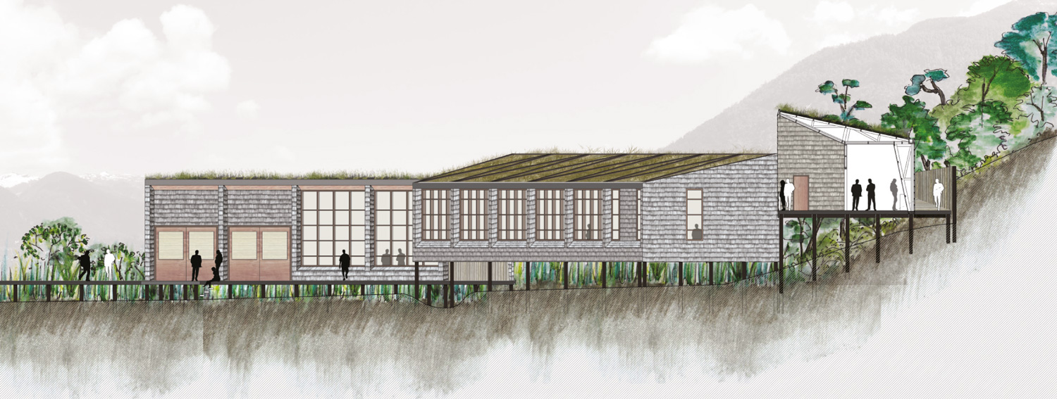
Figure 21.
21
Research Pavilion section.
Notes
1
The CIDEZE is part of the Undersecretariat of Regional and Administrative Development of Chile (SUBDERE). It was created in 1994 to deal with the problems in the provinces and regions considered Extreme Zones and to seek the reinsertion of those zones in the country´s economic development.
2
This Station is a project of the Pontificia Universidad Católica de Chile on a site acquired in concession for scientific research. The site was chosen jointly with a team from the Instituto de Geografía of the university. The project of this research is part of an academic work, which has not yet taken place.
3
At the beginning of this research there was no detailed cartography or satellite images with good resolution of the site to be intervened, and the road to Bahia Exploradores had not been finished yet.
4
This idea was set forth in the course entitled “Urban Project in Extreme Territories,” given by Professor Eugenio Garcés, Pontificia Universidad Católica de Chile, Architecture School, 2012.
5
To Berque, landscape thought (subject) is a thought whose subject is the landscape. It implies reflection about the landscape. In order for that to exist, he establishes, the landscape must be capable of representing itself so that it can be made a subject of thought.
Source: Augustin Berque, El pensamiento paisajero (Madrid: Biblioteca Nueva, 2009), 20.
6
Ibid., 60.
7
The asqqif is, “as applicable, a sort of loggia (a semi-covered terrace (…) or a sitting room with an open space or a corridor.” It is a space that is generated to permit supervision of the fields. Source: Ibid., 67.
8
In Patagonia the estancias came into being as part of a process related to control of the territory. Source: Liliana Lolich, Patagonia, arquitectura de estancias (Buenos Aires: Cedodal, 2003), 87-89.
9
The neocolonial economic system implanted during colonization of the territory permitted the expansion of techniques and designs throughout Patagonia, imposing industrial prefabrication in a pioneering stage. Source: Ibid., 62.
10
Cristina Felsenhardt, “El Paisaje: en búsqueda de definiciones, argumentos y esclarecimientos,” PhD. diss., Pontificia Universidad Católica de Chile, 2011.
11
Denis Cosgrove, “Observando la naturaleza: el paisaje y el sentido europeo de la vista,” A.G.E. 34 (2002): 64.
12
Michel Collot, “Les enjeux du paysage," in Antonio Costa, Il cinema e le arti visive Antonio Costa, (Turin, It.: Einaudi, 2002), 340.
13
Osvaldo Moreno, “Arquitectura del paisaje, una disciplina transversal e integradora,” Revista CA 147 (2011): 14-19 (16).
14
Richard Forman, Land Mosaics, The Ecology of Landscapes and Regions (Cambridge, UK: Cambridge University Press, 1995), 9.
15
Francesco Careri, Walkscapes. El andar como práctica estética (Barcelona: Gustavo Gili, 2002).
Acknowledgment
This essay arose from the thesis entitled “Inserciones Arquitectónicas en un Paisaje Remoto: Estación Científica en Bahía Exploradores,” written as part of the master's program in Landscape Architecture at the Pontificia Universidad Católica de Chile (PUC), and in collaboration with: Estación Patagonia PUC, Pontificia Universidad Católica de Chile, Observatorio Hombre-Medio Internacional (OHM-I) Bahía Exploradores, LabEx DRIIHM, Instituto Nacional de Estadísticas (INE) of Chile, Centre nacional de la recherche scientifique (CNRS) of France.
I would like to thank the following people who participated in this research: especially the thesis advisor, PhD. Architect Eugenio Garcés, who provided interesting reflections on extreme territories and their habitability; my co-tutor, professor Pablo Osses, of the Institute of Geography at the PUC and the institute at large for the information it provided and the expeditions we made to Exploradores; the CEDEUS (Centro de Desarrollo Urbano Sustentable, PUC) for its support.
Credits
Figures 1 and 6-21: graphic works by Elisa Izquierdo Garcés, 2012-2013.
Figure 3a. © N. Piwonka.
Figure 3b. © S. Correa.
Translation from Spanish by Caroline Escher.
Elisa Izquierdo graduated from the Architecture School of the Pontificia Universidad Católica de Chile, where she received a master´s degree in Landscape Architecture (2013). Since that time she has maintained her relationship with the school as Associate Professor. She has also participated in projects at different scales, ranging from urban parks to schoolyards. Since 2015 she has worked as Coordinator of the Architecture and Landscape Area of the Fundación Patio Vivo in Santiago, Chile.
E-mail: elisaizquierdogarces@gmail.com - mlizquie@uc.cl
Page start
111
Page end
144
Print Publication Date
June, 2017
Electronic Publication Date
Friday, June 30, 2017